
NASA satellite imagery showed that Tropical Cyclone Keni was being battered by vertical wind shear. NASA-NOAA's Suomi NPP satellite revealed that wind shear was pushing the clouds and storms associated with Keni to the southeast of the center.
NASA satellite imagery showed that Tropical Cyclone Keni was being battered by vertical wind shear. NASA-NOAA's Suomi NPP satellite revealed that wind shear was pushing the clouds and storms associated with Keni to the southeast of the center.
Keni is in an environment where vertical wind shear is strong, between 46 and 57 mph (40 and 50 knots/74 and 92 kph). Sea surface temperatures are also too cool to help maintain a tropical cyclone. A tropical cyclone needs sea surface temperatures as warm as 80 degrees Fahrenheit (26.6 degrees Celsius), and Keni is moving over waters only as warm as 25 degrees Celsius.
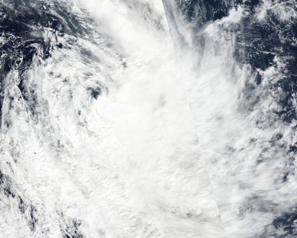
On April 11 the Visible Infrared Imaging Radiometer Suite (VIIRS) instrument aboard NASA-NOAA's Suomi NPP satellite captured a visible image of Tropical Cyclone Keni as it continued moving south and away from Fiji in the Southern Pacific Ocean. The bulk of clouds were pushed east and south of the center of circulation. The image showed that Keni was asymmetric and elongated as northwesterly wind shear stretched the storm out. The image was created at NASA's Goddard Space Flight Center in Greenbelt, Maryland.
Read more at NASA/Goddard Space Flight Center
Image: The VIIRS instrument aboard NASA-NOAA's Suomi NPP satellite captured this visible image of Tropical Cyclone Keni on April 11. The image showed wind shear pushing the bulk of clouds to the southeast of the center. (Credit: NOAA/NASA Rapid Response Team)


