
Tropical Cyclone Mekunu, the second tropical cyclone in less than a week, formed in the western Arabian Sea early on May 22, 2018 and is moving toward a landfall in Oman. NASA satellites provided an infrared, night-time and precipitation analysis of the storm.
Tropical Cyclone Mekunu, the second tropical cyclone in less than a week, formed in the western Arabian Sea early on May 22, 2018 and is moving toward a landfall in Oman. NASA satellites provided an infrared, night-time and precipitation analysis of the storm.
The Global Precipitation Measurement mission or GPM core observatory satellite flew above tropical Cyclone Mekunu in the Arabian Sea on May 22, 2018 at 2:06 p.m. EDT (1806 UTC). GPM's Microwave Imager (GMI) and Dual Frequency Precipitation Radar (DPR) instruments collected data that showed the intensity and location of precipitation within the intensifying tropical cyclone. This GPM pass showed that Mekunu was becoming well organized with maximum sustained wind speeds greater than 45 knots (52 mph). GPM showed that extremely heavy rainfall was located southwest of the center of circulation. GPM's radar (DPR Ku Band) measured precipitation that was falling at a rate of almost 180 mm (7.1 inches) in a few powerful convective storms.
At NASA's Goddard Space Flight Center in Greenbelt, Maryland, the GPM satellite's radar (DPR Ku Band) data were used to create a 3-D structure of precipitation within Mekunu. The 3-D cross-section view of the tropical cyclone's precipitation revealed that powerful convective storms southwest of Mekunu's center were reaching heights of about 16 km (9.9 miles). GPM's DPR showed that some heavy downpours were returning radar reflectivity values greater than 59 dBZ to the satellite. GPM is a joint mission between NASA and the Japan Aerospace Exploration Agency, JAXA.
Read more at NASA/Goddard Space Flight Center
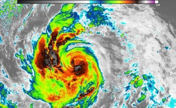
Image: NOAA's Suomi NPP satellite showed cloud top temperatures as cold as or colder than 210 Kelvin (minus 63.1 degrees Celsius/minus 81.6 degrees Fahrenheit) in storms around Mekunu's eye. NASA research has shown that storms with cloud tops that cold have the potential to produce heavy rainfall. (Credit: NASA/NOAA/UWM-SSEC-CIMSS, William Straka III)


