
On Tuesday, May 29, 2018, the National Hurricane Center issued the last public advisory on Alberto. NASA and NOAA satellites continued to provide imagery that showed the extent and strength of the storm in the southern U.S. Alberto has weakened to a subtropical depression.
On Tuesday, May 29, 2018, the National Hurricane Center issued the last public advisory on Alberto. NASA and NOAA satellites continued to provide imagery that showed the extent and strength of the storm in the southern U.S. Alberto has weakened to a subtropical depression.
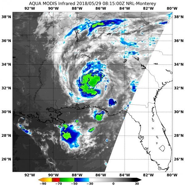
The Moderate Resolution Imaging Spectroradiometer (MODIS) instrument aboard NASA's Aqua satellite captured an infrared image of Subtropical Depression Alberto on May 29 at 4:15 a.m. EDT (0815 UTC) showed strongest storms in three areas circling Alberto's low-level center. The most powerful thunderstorms had cloud top temperatures as cold as or colder than minus 63 degrees Fahrenheit (minus 53 degrees Celsius). Storms with cloud top temperatures that cold have the capability to produce heavy rainfall. That heavy rainfall is a concern and is part of the warning from the National Hurricane Center (NHC).
Read more at NASA / Goddard Space Flight Center
Image: NASA's Aqua satellite captured an infrared image of Subtropical Depression Alberto on May 29 at 4:15 a.m. EDT (0815 UTC) showed strongest storms in three areas circling Alberto's low-level center. The most powerful thunderstorms (yellow) had cloud top temperatures as cold as or colder than minus 63 degrees Fahrenheit (minus 53 degrees Celsius). CREDITS: NASA / NRL


