
The Regional Specialized Meteorological Center in New Delhi (RSMC), India noted on May 25 that Mekunu has now been classified as an Extremely Severe Cyclonic Storm. NASA and NOAA satellites provided visible and infrared imagery of the powerful storm as it headed for landfall in Oman. Mekunu was lashing Oman as a Category 3 hurricane.
The Regional Specialized Meteorological Center in New Delhi (RSMC), India noted on May 25 that Mekunu has now been classified as an Extremely Severe Cyclonic Storm. NASA and NOAA satellites provided visible and infrared imagery of the powerful storm as it headed for landfall in Oman. Mekunu was lashing Oman as a Category 3 hurricane.
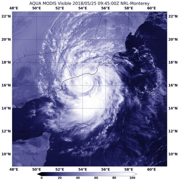
The Moderate Resolution Imaging Spectroradiometer or MODIS instrument aboard NASA's Aqua satellite saw powerful Tropical Cyclone Mekunu in the Arabian Sea on May 25 at 5:45 a.m. EDT (0945 UTC). The Aqua image revealed that Mekunu had developed an eye as it approached landfall in Oman.
Mekunu is now very well defined as compared to its status on May 24. Mekunu has intensified since May 24 according RSMC.
The NOAA-20 satellite captured an infrared image of Mekunu on May 25 that showed temperature data of the cloud tops. Powerful thunderstorms surrounding the low-level center and in a band south of the center had temperatures as cold as or colder than minus 99.6 degrees Fahrenheit (200 kelvin/-73.1 degrees Celsius). NASA research has shown that storms with cloud tops that cold shoot high into the troposphere and have the potential to generate heavy rainfall.
Read more at NASA / Goddard Space Flight Center
Image: NASA's Aqua satellite saw powerful Tropical Cyclone Mekunu in the Arabian Sea on May 25 at 5:45 a.m. EDT (0945 UTC). The Aqua image revealed that Mekunu had developed an eye as it approached landfall in Oman. CREDITS: NASA / NRL


