
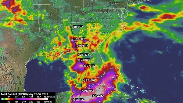
Subtropical Storm Alberto brought soaking rainfall to the southeastern U.S. up through the Tennessee and Ohio Valleys. Using a variety of resources to gather data, including the Global Precipitation Measurement mission or GPM core satellite, NASA estimated the rainfall Alberto created over its path.
Subtropical Storm Alberto brought soaking rainfall to the southeastern U.S. up through the Tennessee and Ohio Valleys. Using a variety of resources to gather data, including the Global Precipitation Measurement mission or GPM core satellite, NASA estimated the rainfall Alberto created over its path.
By May 31, Alberto became a post-tropical cyclone as it moved to exit northeastern lower Michigan.
Alberto's History
Alberto formed out of a broad area of low pressure at the surface that was located over and around the Yucatan Peninsula. Because the area of low pressure was under the influence of a nearby upper-level trough, Alberto was designated as a subtropical storm by the National Hurricane Center (NHC) on the morning of Friday May 25, which is rather unusual as most subtropical storms form at higher latitudes. The storm initially formed just east of the Yucatan Peninsula.
A large subtropical ridge over the southwestern Atlantic steered Alberto on a northward track, and the storm brushed the far western tip of Cuba on Saturday May 26 before the center re-formed as it moved northward into the southeast Gulf of Mexico as a still minimum subtropical storm with maximum sustained winds of around 40 mph. As it moved north further into the Gulf, Alberto initially struggled
to organize and intensify. The storm remained under the influence of an upper-level trough (elongated area of low pressure) with most of the active thunderstorms located well to the east of the center.
Read more at NASA / Goddard Space Flight Center
Image: IMERG rainfall estimates were compiled for the 1-week period from May 23 at 4:30 a.m. EDT (0830 UTC) to May 30 at 4 a.m. EDT (0800 UTC) showed upwards of 500 mm of rain (~20 inches) over the northwestern Caribbean. Rainfall amounts of at least 5 to 15 inches (shown in dark red, purple and pink) cover most of western Cuba. CREDITS: NASA / JAXA, Hal Pierce


