
Tropical Storm Aletta is spinning more than 440 miles off the southwestern coast of Mexico and using satellite data, NASA peered into the storm to uncover where the heaviest rain was falling.
Tropical Storm Aletta is spinning more than 440 miles off the southwestern coast of Mexico and using satellite data, NASA peered into the storm to uncover where the heaviest rain was falling.
Early on June 6, Tropical Depression Two-E was upgraded to Tropical Storm Aletta. This is the first tropical storm of the 2018 eastern North Pacific season. Aletta was located well southwest of Mexico.
The Global Precipitation Measurement mission or GPM core observatory satellite passed above developing tropical storm Aletta on June 6, 2018 at 0046 UTC (June 5 at 8:46 p.m. EDT).
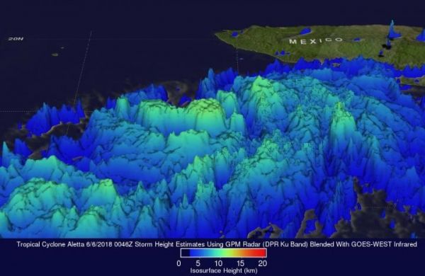
At NASA's Goddard Space Flight Center in Greenbelt, Maryland an image of Aletta's rainfall was created using GPM precipitation measurements. The rainfall was calculated from data collected by GPM's Microwave Imager (GMI) and Dual Frequency Precipitation Radar (DPR) instruments. The satellite's GMI and DPR instruments had a good view of rainfall on Aletta's eastern side. Intense rain bands are shown by DPR spiraling into the tropical cyclone's eastern side. DPR found that rain in some of these powerful storms was falling at a rate of over 187 mm (7.4 inches).
Read more at NASA/Goddard Space Flight Center
Image: NASA analyzed the rainfall rates within Tropical Storm Aletta on June 6, 2018 at 0046 UTC (June 5 at 8:46 p.m. EDT). Intense rain bands are spiraling into the tropical cyclone's eastern side. NASA's GPM satellite found that rain in some of these powerful storms was falling at a rate of over 187 mm (7.4 inches). Storm top heights were found by DPR reaching altitudes of over 12 km (10.5 miles) within powerful storms in rain bands wrapping around Aletta's eastern side. (Credit: NASA/JAXA, Hal Pierce)


