
Tropical Cyclone Ewiniar made landfall on mainland China and as the center of circulation has moved back into the South China Sea and reorganized, NASA-NOAA's Suomi NPP provided a look at the storm.
Tropical Cyclone Ewiniar made landfall on mainland China and as the center of circulation has moved back into the South China Sea and reorganized, NASA-NOAA's Suomi NPP provided a look at the storm.
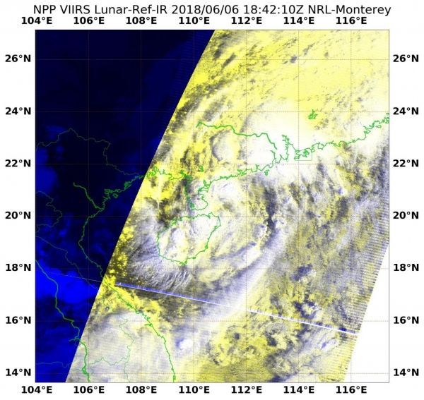
On June 6 at 2:42 p.m. EDT (1842 UTC) the Visible Infrared Imaging Radiometer Suite (VIIRS) instrument aboard NASA-NOAA's Suomi NPP satellite captured an infrared image of Ewiniar. VIIRS is a scanning radiometer That means as the satellite orbits the Earth, VIIRS scans a swath that is ~3040 km wide (the cross-track direction).
The VIIRS image showed that Ewiniar's center was just northeast of Hainan Island, China. Bands of thunderstorms from Ewiniar's southwestern quadrant blanketed Hainan Island.
On June 6 at 1500 UTC (11 a.m. EDT) Ewiniar regained strength in the warm waters of the South China Sea, and has for the second time become a tropical storm. Maximum sustained winds were near 40 mph (35 knots/65 kph).
Read more at NASA/Goddard Space Flight Center
Image: On June 6 at 2:42 p.m. EDT (1842 UTC) the VIIRS instrument aboard NASA-NOAA's Suomi NPP satellite captured an infrared image of Tropical Depression Ewiniar, centered just northeast of Hainan Island, China. (Credit: NOAA/NASA Goddard Rapid Response Team)


