
When NASA's Aqua satellite passed over Aletta in the Eastern Pacific Ocean it had just become the first hurricane of the season. Infrared imagery showed that Aletta appeared more organized. The National Hurricane Center noted that Aletta could become a Category 4 hurricane later on June 8.
When NASA's Aqua satellite passed over Aletta in the Eastern Pacific Ocean it had just become the first hurricane of the season. Infrared imagery showed that Aletta appeared more organized. The National Hurricane Center noted that Aletta could become a Category 4 hurricane later on June 8.
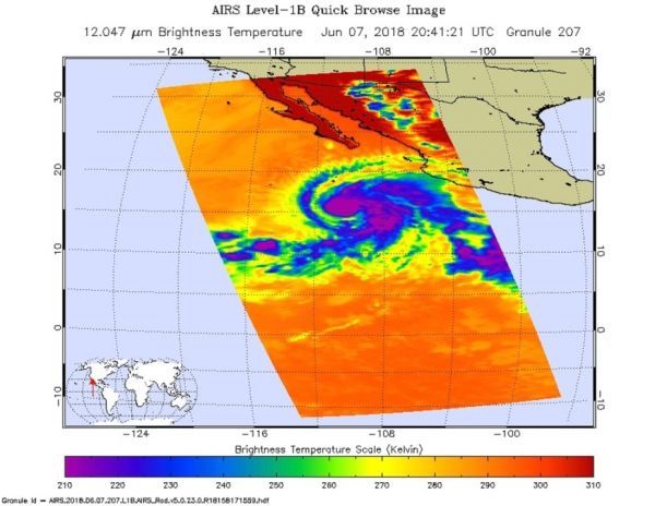
NASA's Aqua satellite passed over Hurricane Aletta on June 7 at 4:41 p.m. EDT (2041 UTC). The Atmospheric Infrared Sounder or AIRS instrument analyzed the storm in infrared light which provides temperature information. Temperature is important when trying to understand how strong storms can be. The higher the cloud tops, the colder and the stronger they are.
AIRS saw coldest cloud top temperatures around the center of circulation and in thick feeder bands from the south and east of the storm's center. Those cloud top temperatures were as cold as minus 63 degrees Fahrenheit (minus 53 degrees Celsius). Storms with cloud top temperatures that cold have the capability to produce heavy rainfall.
Read more at NASA / Goddard Space Flight Center
NASA's Aqua satellite passed over Hurricane Aletta on June 7 at 4:41 p.m. EDT (2041 UTC) and saw coldest cloud top temperatures (purple) around the center of circulation and in thick feeder bands from the south and east of the storm's center. CREDITS: NASA JPL / Ed Olsen


