
The Pacific island of Guam continued to experience the effects of Typhoon Maria on July 5 as NASA-NOAA's Suomi NPP satellite showed a large band of storms over the island.
Tropical Depression 10W strengthened since July 4 and by July 5 had attained typhoon strength.
The Pacific island of Guam continued to experience the effects of Typhoon Maria on July 5 as NASA-NOAA's Suomi NPP satellite showed a large band of storms over the island.
Tropical Depression 10W strengthened since July 4 and by July 5 had attained typhoon strength.
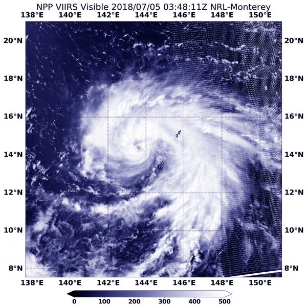
NASA-NOAA’s Suomi NPP satellite flew over Typhoon Maria on July 5 at 0348 UTC (July 4 at 11:48 a.m. EDT). The Visible Infrared Imaging Radiometer Suite (VIIRS) instrument aboard NASA-NOAA's Suomi NPP satellite captured a visible image that showed the center of Maria had moved to the west of Guam, and a large band of thunderstorms wrapping into the center and extended to the east, stretched over the island.
A Flash Flood Watch remains in effect through Friday morning, July 6, for Guam, Rota Tinian and Saipan. When Maria passed over Guam it brought heavy rain. The heavy rain threat continues for the Marianas and excessive rainfall and flash flooding remain possible especially across Guam and Rota. Many locations across Guam already received over 3 inches of rain. In addition, The National Weather Service in Tiyan has issued a Small Craft Advisory, which is in effect until 4 p.m. CHST (local time) on Friday, July 6.
Read more at NASA / Goddard Space Flight Center
Image: NASA-NOAA’s Suomi NPP satellite flew over Typhoon Maria on July 5 at 0348 UTC (July 4 at 11:48 a.m. EDT). The image captured showed that although the center of Maria had moved to the west of Guam, a large band of thunderstorms wrapping into the center and extending to the east, stretched over the island. CREDITS: NASA / NOAA / NRL


