
The hurricane record from the Atlantic Ocean shows phases of high and low activity that can last several decades at a time.
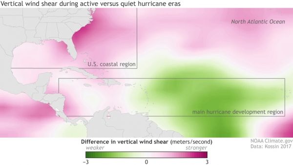
The hurricane record from the Atlantic Ocean shows phases of high and low activity that can last several decades at a time. Active eras spawn more hurricanes per season on average, especially major hurricanes. All else being equal, more major hurricanes overall ought to mean more major hurricane landfalls in the United States, but records show that isn’t the case. These maps show one possible explanation for that puzzle: otherwise active hurricane eras appear to have a built-in speed bump for major hurricanes that approach the U.S.
Based on research by NOAA hurricane expert Jim Kossin, these maps show the difference in vertical wind shear (top) and sea surface temperature (bottom) between the current active hurricane era (1993-2015) and the previous quiet period (1970-1992). Across most of the tropical Atlantic (where hurricanes form), average climate conditions since the mid-1990s have been especially friendly to hurricanes, with higher ocean surface temperatures (darker reds) and weaker vertical wind shear (greens). But over the Gulf of Mexico and off the U.S. southeastern seaboard, the pattern is reversed: cooler temperatures (relative to the main development region) and stronger vertical wind shear, both of which weaken hurricanes.
Continue reading at NOAA.
Image via NOAA.


