
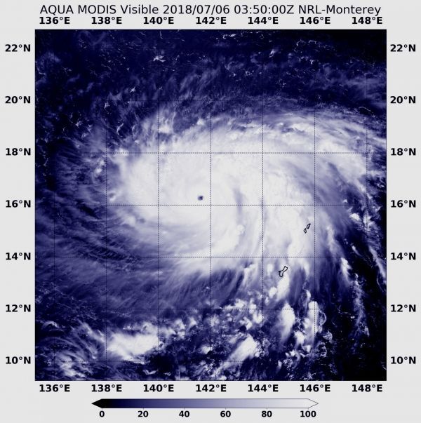
Super Typhoon Maria’s seven nautical-mile wide eye appeared very clearly in a visible image from NASA’s Aqua satellite on July 6.
When NASA’s Aqua satellite passed over the Northwestern Pacific Ocean on July 6 at 0350 UTC (July 5 at 11:50 p.m. EDT), the MODIS instrument or Moderate Resolution Imaging Spectroradiometer provided a visible-light image of Super Typhoon Maria. The MODIS image revealed a clear, small eye, surrounded by a powerful ring of strong thunderstorms.
At 11 a.m. EDT (1500 UTC) on July 6, 2018, the Joint Typhoon Warning Center (JTWC) noted that Super Typhoon Maria was packing maximum sustained winds near 155 mph (135 knots/250 kph). Maria was a strong Category 4 hurricane on the Saffir-Simpson Hurricane Wind Scale. Maria’s eye was centered near 17.0 degrees north latitude and 141.2 degrees east longitude, about 480 nautical miles south of Iwo To island, Japan. Maria was moving to the northwest at 4.6 mph (4 knots/7.4 kph).
Read more at NASA / Goddard Space Flight Center
Image: NASA’s Aqua satellite passed over Super Typhoon Maria on July 6 at 0350 UTC (July 5 at 11:50 p.m. EDT). The MODIS instrument aboard provided an image that revealed a clear, small eye, surrounded by a powerful ring of strong thunderstorms. CREDITS: NASA / NRL


