
NOAA will soon launch a fleet of 15 unmanned gliders in the Caribbean Sea and tropical Atlantic Ocean this hurricane season to collect important oceanic data that could prove useful to forecasters.
NOAA will soon launch a fleet of 15 unmanned gliders in the Caribbean Sea and tropical Atlantic Ocean this hurricane season to collect important oceanic data that could prove useful to forecasters.
“If you want to improve prediction of how hurricanes gain strength or weaken as they travel over the ocean, it's critical to take the ocean’s temperature and measure how salty it is,” said Gustavo Goni, an oceanographer at NOAA’s Atlantic Oceanographic and Meteorological Laboratory who is helping lead the glider research. “Not just at the surface, which we measure with satellites, but down into deeper layers of ocean waters.” (See this video of a typical research glider being used in the Caribbean.)
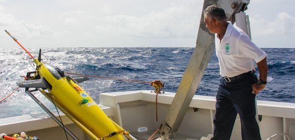
NOAA, the U.S. Integrated Ocean Observing System and university partners will begin deploying the torpedo-shaped, remotely-operated, battery-powered gliders from vessels off Puerto Rico and the U.S. Virgin Islands in mid-July. Ten of the gliders will come from the U.S. Navy, and the others from NOAA.
The gliders will collect the ocean data as they dive down from the surface to a half mile of depth and then regularly resurface several times a day, even during hurricane conditions, to transmit information by satellite to the Global Telecommunications Center used by NOAA’s National Weather Service. The data will be available to the public through the U.S. IOOS Glider Data Assembly Centeroffsite link later this summer.
Continue reading at NOAA.
Image via NOAA.


