
As Tropical Depression 11W was strengthening into Tropical Storm Son-tinh near the northern Philippines, the Global Precipitation Measurement mission or GPM core satellite analyzed its rainfall.
As Tropical Depression 11W was strengthening into Tropical Storm Son-tinh near the northern Philippines, the Global Precipitation Measurement mission or GPM core satellite analyzed its rainfall.
TD11W or Son-Tinh, is the first tropical cyclone of 2018 for the northern Philippines, where the storm is known locally as "Tropical Cyclone Henry."
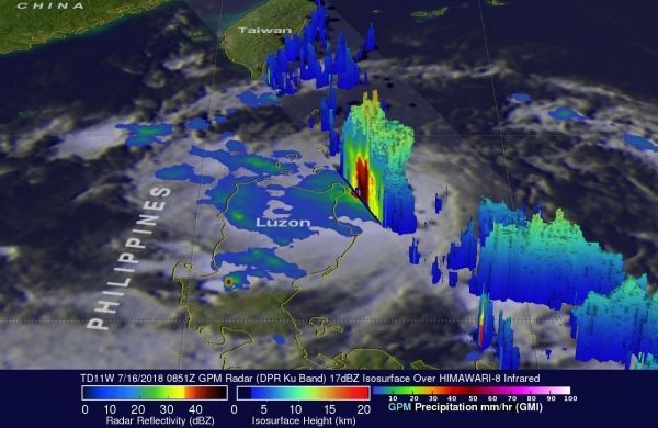
At the time GPM passed overhead, Son-Tinh was still a tropical depression. It was close to the northern Philippines on July 16, 2018 at 4:51 a.m. EDT (0851 UTC). GPM is a joint mission between NASA and the Japan Aerospace Exploration Agency, JAXA.
Data collected by GPM's Microwave Imager (GMI) and Dual-Frequency Precipitation Radar (DPR) instruments showed that the tropical cyclone was relatively small but was dropping moderate to heavy rain over much of the northern Philippine island of Luzon.
Read more at NASA / Goddard Space Flight Center
Image: The GPM core observatory satellite passed over on July 16, 2018 at 4:51 a.m. EDT (0851 UTC), GPM's radar (DPR Ku Band) also showed extremely heavy precipitation in the Philippine Sea near the northeastern tip of Luzon where rain was coming down at a rate of greater than 165 mm (6.5 inches) per hour. CREDITS: NASA / JAXA, Hal Pierce


