
Tropical Storm Jongdari appeared much more organized in visible imagery from NASA’s Terra satellite when passed over the Northwestern Pacific Ocean.
Tropical Storm Jongdari appeared much more organized in visible imagery from NASA’s Terra satellite when passed over the Northwestern Pacific Ocean.
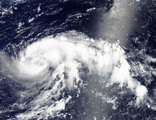
Tropical Depression 15W strengthened into a tropical storm on July 24 at 5 p.m. EDT (2100 UTC) and was renamed “Jongdari.”
On July 25, the Moderate Resolution Imaging Spectroradiometer or MODIS instrument aboard NASA’s Terra satellite obtained a visible image of Tropical Storm Jongdari. The storm appeared more organized with bands of thunderstorms wrapping into the center, and a thick band northeast of the center. Infrared satellite imagery also showed a consolidating system with deep convective banding wrapping into a defined low-level circulation center. Microwave imagery has already revealed an eye feature.
Read more at NASA/Goddard Space Flight Center
Image: NASA's Terra satellite provided a visible look at Tropical Storm Jongdari in the Northwestern Pacific Ocean on July 25. The storm appeared more organized with bands of thunderstorms wrapping into the center, and a thick band northeast of the center. (Credit: NASA)


