
The Global Precipitation Measurement mission or GPM core satellite provided a rainfall and cloud analysis on powerful Typhoon Jongdari as it moves toward Japan. Jongdari follows another powerful typhoon that made landfall in Japan earlier this year.
The Global Precipitation Measurement mission or GPM core satellite provided a rainfall and cloud analysis on powerful Typhoon Jongdari as it moves toward Japan. Jongdari follows another powerful typhoon that made landfall in Japan earlier this year.
A tropical cyclone called Prapiroon formed in late June and impacted Japan and South Korea as a typhoon in early July. Record breaking rainfall that began with Prapiroon caused flooding, landslides and many deaths. Today, another called Typhoon Jongdari is located in the northern Pacific Ocean to the southeast of Japan. It is also expected to hit southern Japan and possibly affect South Korea as it is steered toward the northwest from its current position.
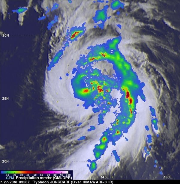
Intensifying Typhoon Jongdari had maximum sustained winds estimated at 90 knots (104 mph) when the GPM core observatory satellite passed over it on July 27, 2018 at 0358 UTC (July 26 at 11:58 p.m. EDT). GPM is a joint mission between NASA and the Japan Aerospace Exploration Agency JAXA.
Read more at NASA / Goddard Space Flight Center
Image: On July 27, 2018 at 0358 UTC (July 26 at 11:58 p.m. EDT), GPM's data indicated that precipitation was falling at a rate of over 267 mm (10.5 inches) per hour in a band of rain well to the northwest of the typhoon's center. The most extreme rainfall rates were measured by DPR in a large feeder band on the eastern side of the typhoon. GPM's radar indicated that rain in those storms was falling at a rate of over 277 mm (10.9 inches) per hour. CREDITS: NASA / JAXA, Hal Pierce


