
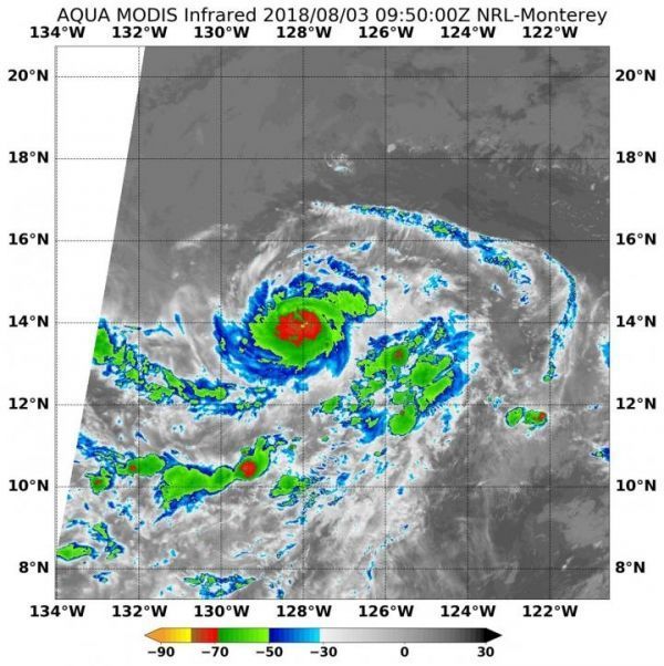
Hurricane Hector has a small, tight center surrounded by strong storms. Infrared satellite imagery provides temperature data, and when NASA's Aqua satellite passed over Hector the coldest cloud tops circling the center were compact.
Hurricane Hector has a small, tight center surrounded by strong storms. Infrared satellite imagery provides temperature data, and when NASA's Aqua satellite passed over Hector the coldest cloud tops circling the center were compact.
Cloud top temperatures determine strength of the thunderstorms that make up a tropical cyclone. The colder the cloud top, the stronger the uplift in the storm that helps thunderstorm development. Basically, infrared data helps determine where the most powerful storms are within a tropical cyclone.
The Moderate Resolution Imaging Spectroradiometer or MODIS instrument aboard Aqua provided that infrared data on Aug. 3 at 5:50 a.m. EDT (0950 UTC). MODIS data showed the strongest thunderstorms were as cold or colder than minus 70 degrees Fahrenheit (minus 56.6 degrees Celsius). NASA research indicates very cold cloud tops with the potential to generate very heavy rainfall.
Read more at NASA/Goddard Space Flight Center
Image: On Aug. 3 at 5:50 a.m. EDT (0950 UTC) NASA's Aqua satellite revealed some cloud top temperatures in strong storms around Hurricane Hector's compact center were as cold or colder than minus 70 degrees (red) Fahrenheit (minus 56.6 degrees Celsius). (Credit: NASA/NRL)


