
Tropical Storm Ileana continued to move north along the coast of western Mexico on Aug. 7 but cloud tops warmed as a result of interaction with land and nearby Hurricane John. Infrared data from NASA's Aqua satellite provided forecasters with temperature data that showed cloud top temperatures in Ileana were strongest around its center.
Tropical Storm Ileana continued to move north along the coast of western Mexico on Aug. 7 but cloud tops warmed as a result of interaction with land and nearby Hurricane John. Infrared data from NASA's Aqua satellite provided forecasters with temperature data that showed cloud top temperatures in Ileana were strongest around its center.
Despite moving along the coast, Ileana is keep enough distance so that the Government of Mexico has discontinued the Tropical Warning for southwestern Mexico.
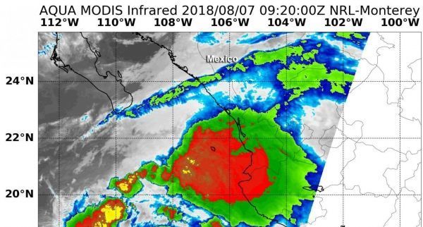
On Aug. 7 at 4:20 a.m. EDT (0920 UTC) the Moderate Resolution Imaging Spectroradiometer or MODIS instrument aboard NASA's Aqua satellite analyzed Tropical Storm Ileana's cloud top temperatures in infrared light. MODIS found cloud top temperatures of strongest thunderstorms were located around the center. In that area, cloud top temperatures were as cold as or colder than minus 70 degrees (red) Fahrenheit (minus 56.6 degrees Celsius). Those cloud top temperatures had warmed since the previous day, indicating a weakening of the storm.
However, cloud top temperatures that cold indicate strong storms that have the capability to create heavy rain.
Read more at NASA/Goddard Space Flight Center
Image: On Aug. 7 at 4:20 a.m. EDT (0920 UTC) NASA's Aqua satellite found coldest temperatures of strongest thunderstorms (yellow) in Tropical Storm Ileana were as cold as or colder than minus 70 degrees (red) Fahrenheit (minus 56.6 degrees Celsius). (Credit: NRL/NASA)


