
Hurricane Hector maintained its major hurricane status on Aug. 8 as NASA's Aqua satellite passed overhead. Infrared data from NASA's Aqua satellite provided forecasters with cloud top temperatures in Hector so they could pinpoint the strongest part of the storm.
Hurricane Hector maintained its major hurricane status on Aug. 8 as NASA's Aqua satellite passed overhead. Infrared data from NASA's Aqua satellite provided forecasters with cloud top temperatures in Hector so they could pinpoint the strongest part of the storm.
NOAA's Central Pacific Hurricane Center (CPHC) noted today, Aug. 8 that a Tropical Storm Warning is in effect for Hawaii County. A Tropical Storm Warning means that tropical storm conditions are expected somewhere within the warning area later today.
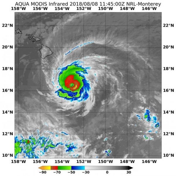
On Aug. 8 at 7:45 a.m. EDT (1145 UTC) the Moderate Resolution Imaging Spectroradiometer or MODIS instrument aboard NASA's Aqua satellite analyzed Hurricane Hector's cloud top temperatures in infrared light. MODIS found cloud top temperatures of the strongest thunderstorms were as cold as or colder than minus 80 degrees Fahrenheit (minus 62.2 Celsius) around the center. Cloud top temperatures that cold indicate strong storms that have the capability to create heavy rain.
At 11 a.m. EDT (5 a.m. HST/1500 UTC), the center of Hurricane Hector was located near latitude 16.4 degrees north and longitude 153.9 degrees west. That's about 240 miles (390 km) south-southeast of Hilo, Hawaii. Hector is moving toward the west near 16 mph (26 kph), and this motion is expected to continue through Thursday night, Aug. 9.
Read more at NASA/Goddard Space Flight Center
Image: On Aug. 8 at 7:450 a.m. EDT (1145 UTC) NASA's Aqua satellite found coldest temperatures of strongest thunderstorms (yellow) in Hurricane Hector were as cold as or colder than minus 80 degrees Fahrenheit (minus 62.2 Celsius). Hawaii is seen top left. (Credit: NRL/NASA)


