
Tropical Storm Bebinca formed quickly in the northern part of the South China Sea. Warnings were in effect as NASA's Aqua satellite analyzed the storm located off the coast of southern China near Hainan Island and found powerful storms capable of dropping heavy rainfall.
Tropical Storm Bebinca formed quickly in the northern part of the South China Sea. Warnings were in effect as NASA's Aqua satellite analyzed the storm located off the coast of southern China near Hainan Island and found powerful storms capable of dropping heavy rainfall.
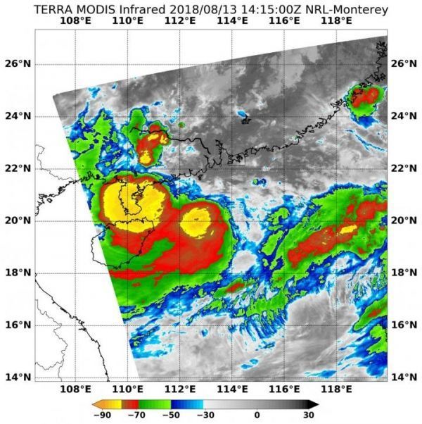
On Aug. 13 at 10:15 a.m. EDT (1415 UTC) the Moderate Resolution Imaging Spectroradiometer or MODIS instrument aboard NASA's Aqua satellite analyzed Tropical Storm Bebinca's cloud top temperatures in infrared light. MODIS found cloud top temperatures of strongest thunderstorms were as cold as or colder than minus 80 degrees Fahrenheit (minus 62.2 Celsius) around the center. Cloud top temperatures that cold indicate strong storms that have the capability to create heavy rain.
On Aug. 13, a Tropical Cyclone Warning Bulletin was issued by the Hong Kong Observatory (HKO) and Standby Signal, No. 1 was in force. That means that a tropical cyclone now centered within about 800 kilometers (497 miles) of Hong Kong.
Read more at NASA/Goddard Space Flight Center
Image: On Aug. 13 at 10:15 a.m. EDT (1415 UTC) NASA's Aqua satellite found coldest temperatures of strongest thunderstorms (yellow) in Tropical Storm Bebinca were as cold as or colder than minus 80 degrees Fahrenheit (minus 62.2 Celsius). (Credit: NRL/NASA)


