
NASA provided estimates monsoon rainfall that affected India from Aug. 13 to 20.
The above average monsoon rains resulted in severe flooding in parts of India. Hardest hit was the state of Kerala located in the southwest corner near the bottom of the peninsula where at least 350 fatalities have been reported and many as 800,000 people displaced as a result of the extreme flooding and ensuing mudslides.
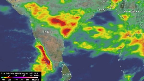
The summer monsoon is a regular feature this time of year in India, and it can bring heavy rains to the region. However, periodically areas of low pressure can form within the general monsoon trough and bring even more rain.
Although the extreme Himalayan topography located to the north is much more well-known, another contributing factor to the heavy rains along the southwest coast of India is the Western Ghats. Though much smaller than the Himalayas, this mountain range runs parallel to the West Coast of India with many peaks over 2,000 meters (~6,500 feet). As a result, the Western Ghats are well positioned to enhance rainfall along the West Coast of India as they intercept the moisture laden air being drawn in off the warm waters of the northern Indian Ocean and Arabian Sea as part of the southwest monsoon circulation.
Read more at NASA / Goddard Space Flight Center
Image: Rainfall accumulations from Aug. 13 to 20, 2018 showed two bands of heavy rain across India. The first band appeared much broader and extends across the northern part of the peninsula with weekly rainfall totals ranging from over 120 mm (~5 inches, in yellow) towards the western half of the peninsula to as much as 350 mm (~14 inches, in dark red) over parts of the eastern half towards the Bay of Bengal. The second band was more concentrated, intense and closely aligned with the southwest coast of India and the Western Ghats. Rainfall totals in this band are generally over 250 mm (~10 inches, in red) with embedded areas exceeding 400 mm (~16 inches, in purple). The maximum estimated value from IMERG in this band was 469 mm (~18.5 inches). CREDITS: NASA / JAXA / SSAI / Hal Pierce


