
NASA’s Aqua satellite provided valuable infrared temperature data on Category 4 Hurricane Norman that showed its strongest storms were southeast of center.
NASA’s Aqua satellite provided valuable infrared temperature data on Category 4 Hurricane Norman that showed its strongest storms were southeast of center.
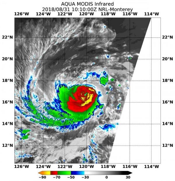
On Aug. 31 at 6:10 a.m. EDT (1010 UTC) the Moderate Resolution Imaging Spectroradiometer or MODIS instrument aboard NASA’s Aqua satellite found the coldest temperatures of the strongest thunderstorms in Hurricane Norman were southeast of the center and were as cold as or colder than minus 80 degrees Fahrenheit (minus 62.2 Celsius). They were embedded in a large area of storms where cloud top temperatures were as cold as or colder than minus 70 degrees Fahrenheit (minus 56.6 degrees Celsius). NASA research has shown that storms with cloud top temperatures that cold (that are very high in the troposphere) have the capability to generate heavy rain.
There are no coastal watches or warnings in effect as Norman is far from land. It is 825 miles (1,330 km) west-southwest of the southern tip of Baja California.
Read more at NASA / Goddard Space Flight Center
Image: On Aug. 31 at 6:10 a.m. EDT (1010 UTC) NASA’s Aqua satellite found the coldest temperatures of the strongest thunderstorms (yellow) in Hurricane Norman were as cold as or colder than minus 80 degrees Fahrenheit (minus 62.2 Celsius) southeast of the center. They were embedded in a large area of storms (red) where cloud top temperatures were as cold as or colder than minus 70 degrees Fahrenheit (minus 56.6 degrees Celsius). CREDITS: NRL / NASA


