
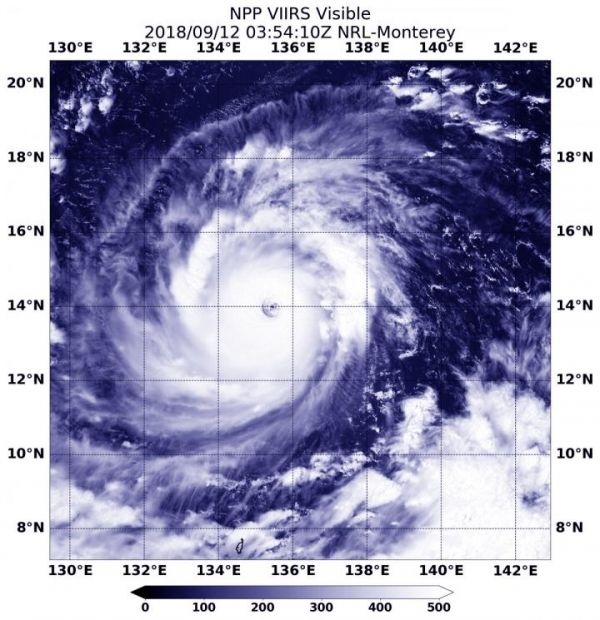
NASA-NOAA’s Suomi NPP satellite passed directly over Super Typhoon Mangkhut from space and stared down its almost 30 nautical-mile-wide eye to the waters of the Northwestern Pacific Ocean. Mangkhut is threatening the northern Philippines where is known as Ompong.
NASA-NOAA’s Suomi NPP satellite passed directly over Super Typhoon Mangkhut from space and stared down its almost 30 nautical-mile-wide eye to the waters of the Northwestern Pacific Ocean. Mangkhut is threatening the northern Philippines where is known as Ompong.
At 10 a.m. EDT (10 p.m. local time, Philippines) on Sept. 12, the eye of Typhoon Mangkhut was located approximately 1,005 km East of Virac, Catanduanes, Philippines near 14.3 degrees north latitude and 133.5 degrees east longitude. Maximum sustained winds were near 172 mph (150 knots/277 kph).
The Philippine Atmospheric, Geophysical, and Astronomical Services Administration (PAGASA) noted that the typhoon continues to threaten Northern Luzon.
Read more at NASA/Goddard Space Flight Center
Image: Visible imagery on Sept. 11 at 11:44 p.m. EDT (Sept. 12 at 0354 UTC) from the Visible Infrared Imaging Radiometer Suite (VIIRS) instrument aboard NASA-NOAA's Suomi NPP satellite flew directly over Super Typhoon Mangkhut and stared into its eye. (Credit: NASA/NOAA/NRL)


