
NASA-NOAA’s Suomi NPP satellite passed over the eye of powerful Category 4 Hurricane Florence and found the storm over 400 miles in diameter and the capability to generate very heavy rainfall.
NASA-NOAA’s Suomi NPP satellite passed over the eye of powerful Category 4 Hurricane Florence and found the storm over 400 miles in diameter and the capability to generate very heavy rainfall.
At 8 a.m. EDT on Wednesday, Sept. 12, NOAA’s National Hurricane Center (NHC) warned “Dangerous Florence heading toward the U.S. southeast coast and is expected to bring life-threatening storm surge and rainfall to portions of the Carolinas and Mid-Atlantic States.”
Putting the Size and Surge of the Storm in Perspective
Florence is about 400 miles in diameter. For an understanding of how large the system is 400 miles is the distance from Baltimore, Maryland to Boston, Massachusetts.
This is a life-threatening situation. In some areas, the NHC said that storm surge could be as high as 13 feet, which is over the first floor of a house or building.
Read more at NASA/Goddard Space Flight Center
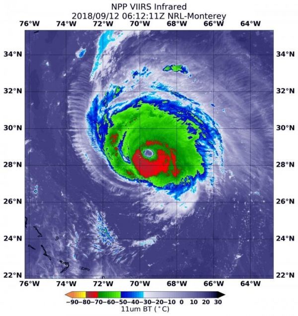
Image: On Sept. 12, 2018 at 2:12 a.m. EDT (0612 UTC) the VIIRS instrument aboard NASA-NOAA's Suomi NPP satellite captured an infrared image of powerful Hurricane Florence with a very distinct eye. Coldest cloud top temperatures (yellow) of strongest thunderstorms were in the eyewall, the area of thunderstorms surrounding the open eye. Those storms had cloud tops as cold as or colder than minus 80F/minus 62.2C. They were surrounded by powerful storms (red) with cloud tops as cold as minus 70F/minus 56.6C. (Credit: NOAA/NASA/NRL)


