
NASA’s Aqua satellite provided an infrared look at a weakening and now tropical depression Olivia in the Central Pacific Ocean. Olivia soaked the Hawaiian Islands on its east to west track through them.
NASA’s Aqua satellite provided an infrared look at a weakening and now tropical depression Olivia in the Central Pacific Ocean. Olivia soaked the Hawaiian Islands on its east to west track through them.
The Central Pacific Hurricane Center or CPHC noted now that Olivia’s center has moved west of the Hawaiian Islands, as such there are no coastal watches or warnings in effect. However, interests in the northwest Hawaiian Islands should monitor the progress of Olivia.
On Sept. 13, Olivia was moving rapidly toward the west-southwest, far southwest of Hawaii, however, flooding rainfall continues across parts of the main Hawaiian Islands.
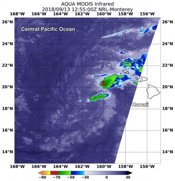
At 2:20 a.m. EDT (0230 UTC) on Sept. 13, Moderate Resolution Imagine Spectroradiometer or MODIS instrument aboard NASA’s Aqua satellite analyzed Tropical Depression Olivia in infrared light. MODIS found coldest cloud top temperatures in powerful storms with cloud tops as cold as or colder than minus 70F (minus 56.6C) west of the Hawaiian Islands. NASA research has found that cloud top temperatures as cold as or colder than the 70F/56.6C threshold have the capability to generate heavy rainfall.
Read more at NASA/Goddard Space Flight Center
Image: At 8:55 a.m. EDT (1255 UTC) on Sept. 13, the MODIS instrument aboard NASA's Aqua satellite looked at Tropical Depression Olivia in infrared light. MODIS found a small area of powerful storms with cloud tops as cold as or colder than minus 70 degrees (red) Fahrenheit (minus 56.6 degrees Celsius) west of the Hawaiian Islands. (Credit: NASA/NRL)


