
NASA’s Aqua satellite provided an infrared look at powerful Super Typhoon Mangkhut early on Sept. 13 that revealed a large eye surrounded by a large area of powerful storms. Mangkhut is a Category 5 storm.
NASA’s Aqua satellite provided an infrared look at powerful Super Typhoon Mangkhut early on Sept. 13 that revealed a large eye surrounded by a large area of powerful storms. Mangkhut is a Category 5 storm.
The Joint Typhoon Warning Center noted that “animated enhanced infrared satellite imagery shows deepening or strengthening convection (rising air that forms the thunderstorms that make up a tropical cyclone) with colder cloud tops.” Colder cloud tops mean that the uplift of air has strengthened and pushed cloud tops higher in the troposphere. The higher and colder the cloud top, the stronger the storm and the greater potential for heavier rainfall.
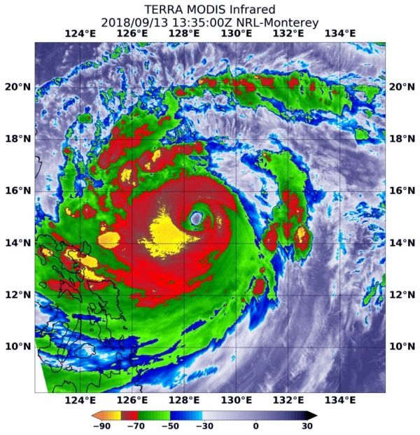
At 9:35 a.m. EDT (1335 UTC) on Sept. 13, the MODIS instrument aboard NASA’s Aqua satellite looked at Typhoon Mangkhut in infrared light as it was approaching the Philippines. MODIS saw that Mangkhut has a 27 nautical-mile-wide eye.
Read more at NASA / Goddard Space Flight Center
Image: At 9:35 a.m. EDT (1335 UTC) on Sept. 13, the MODIS instrument aboard NASA’s Aqua satellite looked at Super Typhoon Mangkhut in infrared light as it was approaching the Philippines. MODIS found coldest cloud top temperatures around the eye, as cold as or colder than minus 80 degrees (yellow) Fahrenheit (minus 112 degrees Celsius). Surrounding the eye were thick rings of powerful storms with cloud tops as cold as or colder than minus 70 degrees (red) Fahrenheit (minus 56.6 degrees Celsius). CREDIT: NASA / NRL


