
NASA-NOAA’s Suomi NPP satellite passed over the eye of Hurricane Florence the morning of landfall. Infrared imagery showed the power and the extent of this massive storm.
NASA-NOAA’s Suomi NPP satellite passed over the eye of Hurricane Florence the morning of landfall. Infrared imagery showed the power and the extent of this massive storm.
The National Hurricane Center or NHC said on Sept. 14, “Life-threatening storm surges and hurricane-force winds continue and catastrophic freshwater flooding expected over portions of North and South Carolina.”
Hurricane Florence made landfall near Wrightsville Beach, North Carolina at 7:15 AM EDT (1115 UTC) with estimated maximum winds of 90 mph (150 km/h), and a minimum central pressure estimate of 958 millibars.
Four hours before landfall NASA- NOAA’s Suomi NPP satellite analyzed the large storm.
A NASA Satellite View of a Massive Rainmaker
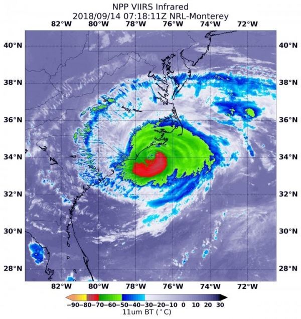
On Sept. 14 at 3:18 a.m. EDT (0718 UTC) the Visible Infrared Imaging Radiometer Suite (VIIRS) instrument aboard NASA-NOAA’s Suomi NPP satellite captured an infrared view of Florence. VIIRS infrared imagery showed that the eye of Florence appeared ragged.
Read more at NASA/Goddard Space Flight Center
Image: On Sept. 14, 2018 at 3:18 a.m. EDT (0718 UTC) the VIIRS instrument aboard NASA-NOAA's Suomi NPP satellite captured an infrared image of powerful Hurricane Florence with a ragged eye. Coldest cloud top temperatures (yellow) of strongest thunderstorms were in the eyewall, the area of thunderstorms surrounding the open eye. Those storms had cloud tops as cold as or colder than minus 80F/minus 62.2C. They were surrounded by powerful storms (red) with cloud tops as cold as minus 70F/minus 56.6C. (Credit: NOAA/NASA/NRL)


