
Tropical Storm Helene may be battling wind shear but it’s caused a Tropical Storm Warning for all of the Azores Islands on Sept. 15. NASA-NOAA’s Suomi NPP satellite passed over the eastern Atlantic Ocean and analyzed the storm.
Tropical Storm Helene may be battling wind shear but it’s caused a Tropical Storm Warning for all of the Azores Islands on Sept. 15. NASA-NOAA’s Suomi NPP satellite passed over the eastern Atlantic Ocean and analyzed the storm.
Southwesterly shear continues to affect now Tropical Storm Helene as it nears the Azores. In general, wind shear is a measure of how the speed and direction of winds change with altitude. Winds at different levels of the atmosphere pushed against the cylindrical circulation center and skewed it, weakening the rotation.
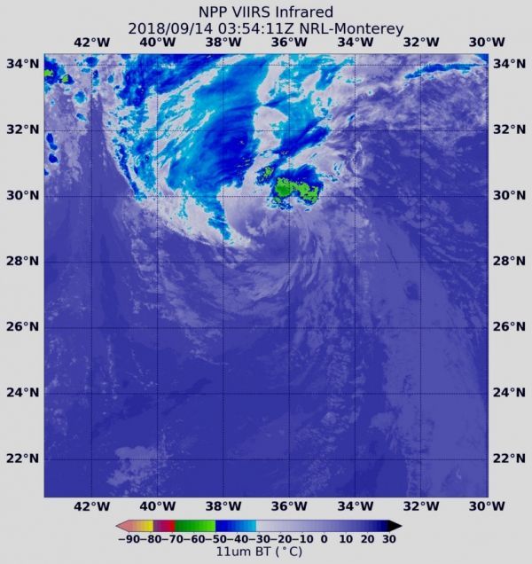
On Sept. 14 at 1:36 a.m. EDT (0536 UTC) the Visible Infrared Imaging Radiometer Suite (VIIRS) instrument aboard NASA-NOAA’s Suomi NPP satellite captured an infrared image of Tropical Storm Helene. VIIRS showed wind shear was pushing all of the strongest storms northeast of center. In that quadrant of the storm, the coldest cloud top temperatures of strongest thunderstorms were as cold as minus 50 degrees Fahrenheit/minus 45.5 degrees Celsius.
Read more at NASA / Goddard Space Flight Center
Image: On Sept. 14 at 0354 UTC (Sept. 13 at 11:54 p.m. EDT) the VIIRS instrument aboard NASA-NOAA’s Suomi NPP satellite captured an infrared image of Tropical Storm Helene. Coldest cloud top temperatures (yellow) of strongest thunderstorms were as cold as minus 50F/minus 45.5C, pushed northeast of the center. Credit: NOAA / NASA / NRL


