
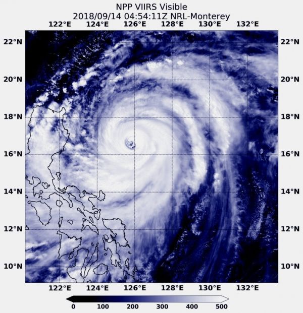
Super Typhoon Mangkhut is a powerful tropical cyclone headed toward the northern Philippines. It is a Category 5 storm on the Saffir-Simpson hurricane wind scale. NASA-NOAA’s Suomi NPP satellite provided a visible image as it passed over the Northwestern Pacific Ocean and stared the storm in its eye.
Super Typhoon Mangkhut is a powerful tropical cyclone headed toward the northern Philippines. It is a Category 5 storm on the Saffir-Simpson hurricane wind scale. NASA-NOAA’s Suomi NPP satellite provided a visible image as it passed over the Northwestern Pacific Ocean and stared the storm in its eye.
Many warnings are posted in the Philippines. They include: Public storm warning signal #3 for the Luzon provinces of Batanes, southern Isabela, Ilocos Sur, La Union, Mountain Province, Benguet, Ifugao, Nueva Vizcaya, Quirino, Northern Aurora. Public storm warning signal #2 is in effect for the Luzon provinces of Pangasinan, Tarlac, Nueva Ecija, southern Aurora, Zambales, Pampanga, Bulacan, Northern Quezon incl. Polillo Island. Public storm warning signal #1 is in effect for the Luzon provinces of Bataan, Rizal, Metro Manila, Cavite, Batangas, Laguna, Rest of Quezon, Lubang Is.,Marinduque, Camarines Norte, Camarines Sur, Catanduanes, Albay, Burias Island.
Read more at NASA / Goddard Space Flight Center
Image: At 12:54 a.m. EDT (0454 UTC) on Sept. 14, the VIIRS instrument aboard NASA-NOAA’s Suomi NPP satellite captured a visible image of Super Typhoon Mangkhut approaching the Philippines. CREDIT: NASA / NRL


