
When NASA’s Aqua satellite passed over the Eastern Pacific Ocean, water vapor data provided information about the intensity of Hurricane Rosa. On Sept. 28, Rosa is a major hurricane, now a Category 4 on the Saffir-Simpson Hurricane Wind Scale.
When NASA’s Aqua satellite passed over the Eastern Pacific Ocean, water vapor data provided information about the intensity of Hurricane Rosa. On Sept. 28, Rosa is a major hurricane, now a Category 4 on the Saffir-Simpson Hurricane Wind Scale.
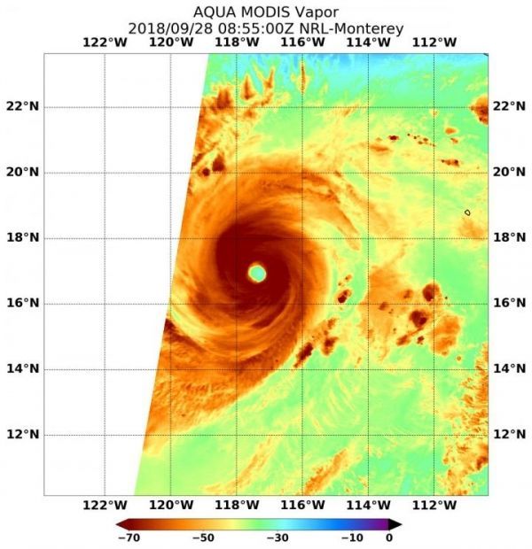
NASA’s Aqua satellite passed Hurricane Rosa on Sept. 28 at 4:55 a.m. EDT (855 UTC) and the Moderate Resolution Imaging Spectroradiometer or MODIS instrument gathered water vapor content and temperature information. The MODIS image showed highest concentrations of water vapor and coldest cloud top temperatures were in a thick ring of storms around the 20 nautical mile-wide eye.
MODIS data also showed coldest cloud top temperatures were as cold as or colder than minus 70 degrees Fahrenheit (minus 56.6 degrees Celsius) in those storms. Storms with cloud top temperatures that cold have the capability to produce heavy rainfall.
Read more at NASA/Goddard Space Flight Center
Image: NASA's Aqua satellite passed over Hurricane Rosa in the Eastern Pacific Ocean on Sept. 28 at 4:55 a.m. EDT (855 UTC) and highest concentrations of water vapor (brown) and coldest cloud top temperatures were around the center. (Credit: NASA/NRL)


