
The Global Precipitation Measurement mission or GPM core satellite passed over the Central Pacific Hurricane Center and analyzed Walaka’s rainfall and cloud structure as it was strengthening into a hurricane.
The Global Precipitation Measurement mission or GPM core satellite passed over the Central Pacific Hurricane Center and analyzed Walaka’s rainfall and cloud structure as it was strengthening into a hurricane.
Walaka formed southwest of the Hawaiian Islands on Saturday, Sept. 29. At 5 p.m. HST on Sunday, Sept. 30, Walaka strengthened to a hurricane.
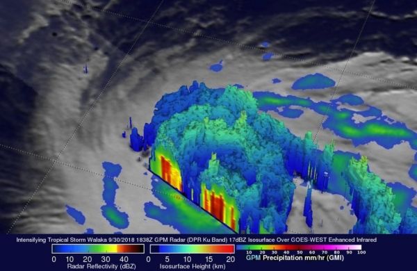
The GPM core observatory recently had a couple good looks at tropical storm Walaka as it was intensifying into a powerful hurricane. GPM passed directly over tropical storm Walaka when it was located south of the Hawaiian Islands on September 30, 2018 at 8:38 a.m. HST (1838 UTC).
Data collected by GPM’s Microwave Imager (GMI) and Dual-Frequency Precipitation Radar (DPR) instruments showed that Walaka was well organized and very close to hurricane intensity. GPM’s Radar (DPR Ku Band) data revealed intense convective storms in a large feeder band that was wrapping around the tropical storm’s northeastern side and storms wrapping around a forming eye wall. GPM’s DPR found rain falling at a rate of almost 6.5 inches (165 mm) per hour in the intense storms in the feeder band northeast of Walaka’s center of circulation.
Read more at NASA / Goddard Space Flight Center
Image: On Sept. 30, GPM data revealed intense convective storms in a large feeder band wrapping around the Tropical Storm Wakala’s northeastern side where rain was falling at a rate of almost 6.5 inches (165 mm) per hour in the intense storms in the feeder band northeast of Walaka’s center of circulation. . A tall convective storm was located in a line northwest of Walaka’s center. It was found by DPR to reach heights above 8.5 miles (13.7 km). CREDIT: NASA/JAXA, Hal Pierce


