
NASA’s Aqua satellite captured an infrared image of Hurricane Leslie that revealed strong storms circled the center.
NASA’s Aqua satellite captured an infrared image of Hurricane Leslie that revealed strong storms circled the center.
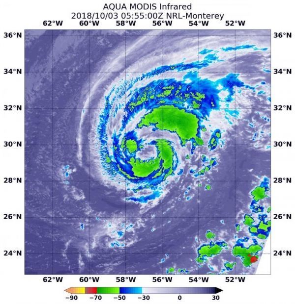
At 1:55 a.m. EDT (0555 UTC) on Oct. 3 the MODIS instrument that flies aboard NASA’s Aqua satellite gathered infrared data on Leslie. Infrared data provides temperature information. Strongest thunderstorms were fragmented as they circled the center and were in a thick band northeast of center where MODIS found cloud top temperatures as cold as minus 63 degrees Fahrenheit (minus 53 Celsius). NASA research has shown that cloud tops with temperatures that cold were high in the troposphere and have the ability to generate heavy rain.
The National Hurricane Center or NHC noted “Deep convection surrounding the center of Leslie has become better organized overnight, with the development of a ragged eye in infrared satellite images.” A microwave image revealed a well-defined low-level eye with a ring of broken convection surrounding it.
Read more at NASA/Goddard Space Flight Center
Image: At 1:55 a.m. EDT (0555 UTC) on Oct. 3, 2018 the MODIS instrument that flies aboard NASA's Aqua satellite gathered infrared data on Hurricane Leslie. Strongest thunderstorms circled the center and were in a thick band northeast of center where cloud top temperatures were as cold as minus 63 degrees Fahrenheit (minus 53 Celsius). (Credit: NASA/NRL)


