
NASA’s Terra satellite analyzed Hurricane Walaka in infrared light as continued to lash the Papahanaumokuakea Marine National Monument in the Central Pacific Ocean.
NASA’s Terra satellite analyzed Hurricane Walaka in infrared light as continued to lash the Papahanaumokuakea Marine National Monument in the Central Pacific Ocean.
NOAA’s Central Pacific Hurricane Center or CPHC said a Tropical Storm Warning is in effect for Papahanaumokuakea Marine National Monument from Nihoa to French Frigate Shoals to Maro Reef.
Papahānaumokuākea Marine National Monument is the largest contiguous fully protected conservation area under the U.S. flag, and one of the largest marine conservation areas in the world, according to the monument’s website. It encompasses 582,578 square miles of the Pacific Ocean (1,508,870 square kilometers) – an area larger than all the country’s national parks combined. The name Papahānaumokuākea commemorates the union of two Hawaiian ancestors – Papahānaumoku and Wākea – who gave rise to the Hawaiian Archipelago, the taro plant, and the Hawaiian people.
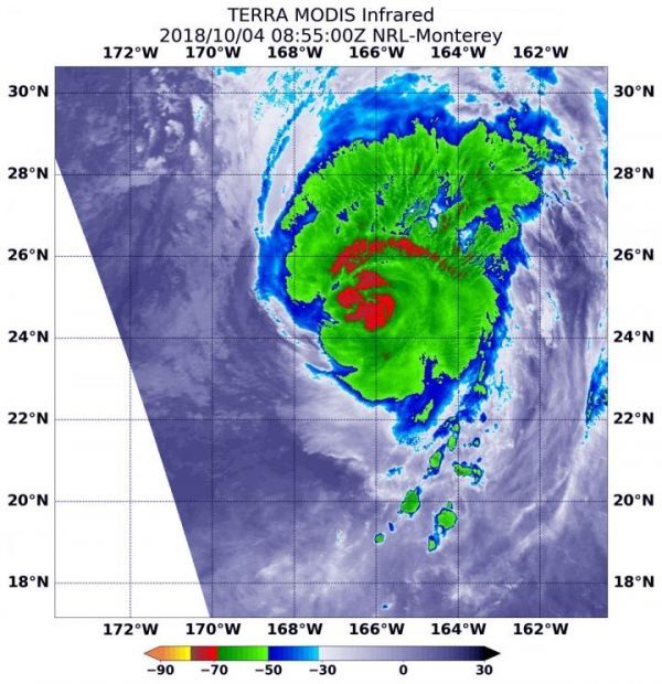
On Oct. 4 at 4:55 a.m. EDT (0855 UTC) the MODIS instrument or Moderate Resolution Imaging Spectroradiometer aboard NASA’s Terra satellite observed Hurricane Walaka and found powerful thunderstorms around the center of circulation. Infrared light that revealed cloud top temperatures were coldest as cold as minus 70 degrees Fahrenheit (minus 56.6 degrees Celsius). NASA research has shown that storms with cloud tops that high in the troposphere and that cold have the capability to generate heavy rain.
Read more at NASA/Goddard Space Flight Center
Image: NASA's Terra satellite observed Hurricane Walaka in the Central Pacific Ocean on Oct. 4 at 4:55 a.m. EDT (0855 UTC). Infrared light that revealed cloud top temperatures were coldest (red) as cold as minus 70 degrees Fahrenheit (minus 56.6 degrees Celsius). (Credit: NASA/NRL)


