
NASA’s Aqua satellite passed over the Central Atlantic Ocean and obtained infrared data on Leslie, now weakened to a large tropical storm.
NASA’s Aqua satellite passed over the Central Atlantic Ocean and obtained infrared data on Leslie, now weakened to a large tropical storm.
The National Hurricane Center or NHC said that Leslie remains a large tropical storm, with tropical-storm-force winds extending outward up to 290 miles (465 km) from the center. Because of the size and strength of Tropical Storm Leslie, waves from Leslie are expected to increase along the coasts of Atlantic Canada and New England today, Oct. 5.
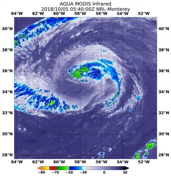
At 1:40 a.m. EDT (0540 UTC) on Oct. 5, the Moderate Resolution Imaging Spectroradiometer or MODIS instrument aboard NASA’s Aqua satellite revealed strongest storms with the coldest cloud top temperatures northwest of Leslie’s center. MODIS found coldest cloud tops had temperatures near minus 63 degrees Fahrenheit (minus 53 degrees Celsius). NASA research has found that cloud top temperatures that cold have the capability to generate heavy rainfall.
Read more at NASA/Goddard Space Flight Center
Image: At 1:40 a.m. EDT (0540 UTC) on Oct. 5, 2018 the MODIS instrument aboard NASA's Aqua satellite revealed strongest storms with the coldest cloud top temperatures (yellow) northwest of Leslie's center with temperatures near minus 63 degrees Fahrenheit (minus 53 degrees Celsius). (Credit: NASA/NRL)


