
The floodwaters that covered wide swaths of the Carolinas’ coastal plain are finally receding, more than two weeks after Hurricane Florence made landfall Sept. 14 near Wrightsville Beach, North Carolina, and U.S. Geological Survey hydrographers are moving in rapidly to the areas where the flooding lingered longest.
The floodwaters that covered wide swaths of the Carolinas’ coastal plain are finally receding, more than two weeks after Hurricane Florence made landfall Sept. 14 near Wrightsville Beach, North Carolina, and U.S. Geological Survey hydrographers are moving in rapidly to the areas where the flooding lingered longest. About 30 flood experts are in the second week of a high water mark campaign, traveling from one hard-hit community to the next, searching neighborhood by neighborhood and sometimes door to door for physical evidence of flooding.
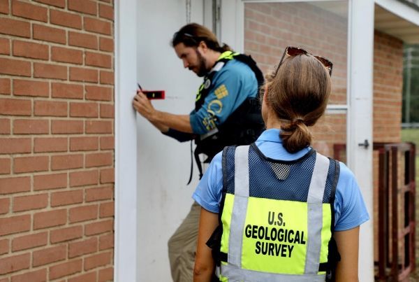
The USGS experts are looking for telltale lines of seeds, leaves, grass blades and other debris left behind on buildings, bridges, other structures and even tree trunks as floodwaters recede. Once they find these high water marks, they label them, photograph them, survey them, and record crucial details about them.
The USGS flood experts’ field work is highly skilled and time-sensitive, because high water marks can be obliterated by weather and by property owners’ cleanup efforts. Hydrographers have been in the field collecting high water marks each day since Sept. 18, working mostly in two-person teams and moving as quickly as receding waters and the scope of the work permits. The teams from the USGS South Atlantic Water Science Center, which covers the Carolinas and Georgia, have recorded more than 600 high water marks in North and South Carolina and surveyed at least 365 of those. Field crews expect to record many more as they move into communities like Conway, South Carolina, where the floodwaters have not yet finished their retreat. You can see some preliminary results of their work at the USGS Flood Event Viewer for Hurricane Florence: https://stn.wim.usgs.gov/FEV/#FlorenceSep2018
Why is this fieldwork important? The physical signs of flooding provide valuable information that can confirm or correct other lines of evidence. Among these are measurements from a network of about 475 permanent and temporary river and streamgages that were in place in North and South Carolina when Florence struck; more than 175 stream and river flow measurements taken by field crews after the storm on flood-swollen rivers, streams and even roads; satellite photos and imagery from unmanned aerial vehicles (or drones); and computer modelled flood projections. Taken together, all this evidence will allow USGS experts to reconstruct precisely where, when, at what depth, and in what volume floodwaters inundated the region.
Continue reading at USGS.
Image via USGS.


