
Over the course of a month, we’ve seen tropical cyclone activity in the Atlantic basin heat up quite a bit – most notably with the landfall of Hurricane Florence, which dumped historic amounts of rain on portions of the Carolinas.
Over the course of a month, we’ve seen tropical cyclone activity in the Atlantic basin heat up quite a bit – most notably with the landfall of Hurricane Florence, which dumped historic amounts of rain on portions of the Carolinas. Although the Atlantic hurricane season runs from June 1 to November 30, on average, early September marks the peak. From 1975 to 2017, there have been an average of 3.1 Atlantic hurricanes per year in September. However, the September of 1998 still holds the record with six hurricanes.
So what makes September historically the most active month for the Atlantic basin?
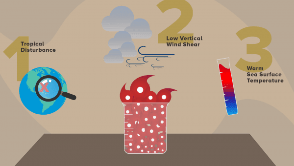
Three basic factors have to come together in September to create the perfect concoction to fuel a hurricane. Hurricane development depends on these three basic factors: sea surface temperature, low vertical wind shear and, of course, a pre-existing disturbance.
First, there has to be a pre-existing tropical disturbance, which usually develops in the form of a tropical wave moving off the coast of Africa. Mark DeMaria with NOAA’s National Hurricane Center explained that tropical cyclones can also form at the end of fronts and as a result of rotation “due to low level westerly winds that move into the Caribbean from the east Pacific late in the hurricane season.”
Continue reading at NOAA.
Image via NOAA.


