
Hurricane Michael continued strengthening while moving north-northwestward over the southeastern Gulf of Mexico as NASA’s Aqua satellite provided infrared and visible imagery of the storm.
Hurricane Michael continued strengthening while moving north-northwestward over the southeastern Gulf of Mexico as NASA’s Aqua satellite provided infrared and visible imagery of the storm.
NOAA’s National Hurricane Center or NHC noted on Oct. 9 that life-threatening storm surge, hurricane force winds and heavy rainfall can be expected along the northeastern gulf coast as Michael continues to move toward landfall.
A Storm Surge Warning is in effect for. Okaloosa/Walton County Line Florida to Anclote River Florida. A Storm Surge Watch is in effect for Anclote River Florida to Anna Maria Island Florida, including Tampa Bay, the Alabama/Florida border to Okaloosa/Walton County Line Florida. A Hurricane Warning is in effect for the Alabama/Florida border to Suwannee River Florida, and a Hurricane Watch is in effect from the Alabama/Florida border to the Mississippi/Alabama border. In addition, a Tropical Storm Warning is in effect from the Alabama/Florida border to the Mississippi/Alabama border and for Suwanee River, Florida to Chassahowitzka, Florida. A Tropical Storm Watch is in effect for Chassahowitzka to Anna Maria Island Florida, including Tampa Bay, the Mississippi/Alabama border to the Mouth of the Pearl River and from Fernandina Beach, Florida to South Santee River, South Carolina.
Read more at NASA / Goddard Space Flight Center
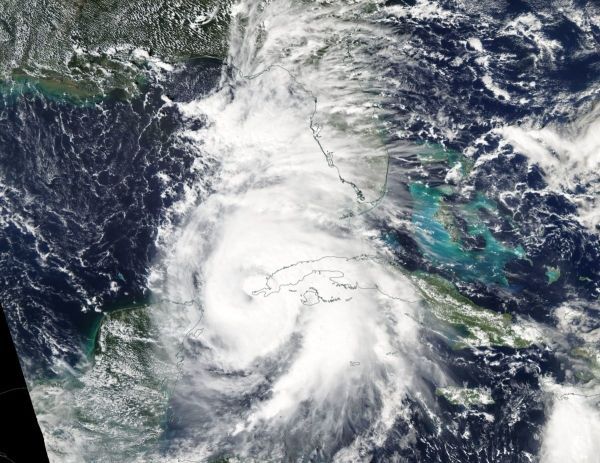
Image: On Oct. 8, the MODIS instrument aboard NASA’s Aqua satellite captured a visible image of Hurricane Michael when it was a Category 1 hurricane near the western tip of Cuba. CREDIT: NASA Worldview, Earth Observing System Data and Information System (EOSDIS)


