
As Hurricane Michael barrels toward the U.S. states along the northwestern Gulf of Mexico, and Tropical Storm Leslie lingers in the Central Atlantic, Tropical Storm Nadine has formed off the west coast of Africa in the far eastern Atlantic. NASA-NOAA’s Suomi NPP satellite provided a visible image of the new named storm.
As Hurricane Michael barrels toward the U.S. states along the northwestern Gulf of Mexico, and Tropical Storm Leslie lingers in the Central Atlantic, Tropical Storm Nadine has formed off the west coast of Africa in the far eastern Atlantic. NASA-NOAA’s Suomi NPP satellite provided a visible image of the new named storm.
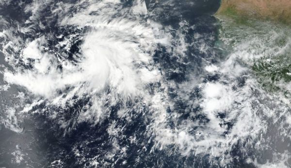
On Oct. 9, the VIIRS instrument aboard NASA-NOAA’s Suomi satellite provided a visible look at Tropical Storm Nadine. The bulk of storms were east to south of center and wrapping into the low-level center.
NOAA’s National Hurricane Center noted st 11 a.m. EDT (1500 UTC) on Oct. 9 the center of Tropical Storm Nadine was located near latitude 10.5 North, longitude 30.0 West. That’s about 480 miles (770 km) southwest of the southernmost Cabo Verde Islands. Nadine is moving toward the west-northwest near 9 mph (15 kph), and this motion is expected to continue through tonight. A motion toward the northwest at a similar forward speed is forecast on Wednesday, Oct. 10 through Friday, Oct. 12. Maximum sustained winds have increased to near 40 mph (65 kph) with higher gusts.
Read more at NASA / Goddard Space Flight Center
Image: On Oct. 9, the VIIRS instrument aboard NASA-NOAA’s Suomi satellite provided a visible look at newly formed Tropical Storm Nadine, located off of Africa’s west coast. CREDIT: NASA Worldview, Earth Observing System Data and Information System (EOSDIS) / NOAA


