
Visible satellite imagery from NASA’s Aqua satellite captured powerful Super Typhoon Yutu as it moved through the Philippine Sea. Yutu’s eye appeared oblong on satellite imagery.
Visible satellite imagery from NASA’s Aqua satellite captured powerful Super Typhoon Yutu as it moved through the Philippine Sea. Yutu’s eye appeared oblong on satellite imagery.
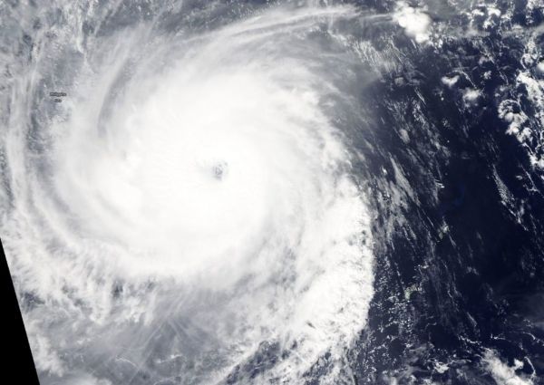
On Oct. 25 at 1:30 p.m. CHST (local time, Guam) the Moderate Resolution Imaging Spectroradiometer or MODIS instrument aboard Aqua captured a visible image of Yutu. The MODIS image showed that large typhoon Yutu continued to remain symmetric with an open 19 nautical-mile-wide eye surrounded by very thick bands of powerful thunderstorms circling the center. At the time of the image, Yutu had passed and cleared Guam.
In satellite imagery on Oct. 26, the eye had become cloud-filled. Infrared satellite imagery revealed cooler cloud tops (indicating the uplift of air had strengthened) and a contracting eye occurring after the storm experienced an eyewall replacement cycle.
Read more at NASA / Goddard Space Flight Center
Image: On Oct. 25 at 1:30 p.m. CHST (local time, Guam) the MODIS instrument aboard Aqua captured a visible image of Typhoon Yutu with a 19 nautical mile oblong eye. CREDIT: NASA Worldview, Earth Observing System Data and Information System (EOSDIS)


