
Visible from NASA’s Aqua satellite revealed the extent of Tropical Storm Xavier into western Mexico from its position just off-shore from Mexico’s Jalisco state.
Visible from NASA’s Aqua satellite revealed the extent of Tropical Storm Xavier into western Mexico from its position just off-shore from Mexico’s Jalisco state.
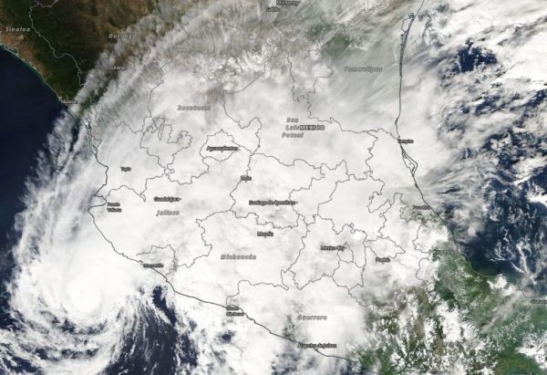
Tropical Depression Twenty-Five-E (25E) formed on Nov. 3 and strengthened in a tropical storm on by 11 p.m. EDT that day. When it became a tropical storm it was re-named Xavier. Xavier has continued to hug the coast of western Mexico since it formed.
On Nov. 4 a visible image from the Moderate Resolution Imaging Spectroradiometer or MODIS instrument aboard NASA’s Aqua satellite showed an organized storm with a thick band of powerful thunderstorms circling the center.
Read more at NASA / Goddard Space Flight Center
Image: On Nov. 4, the MODIS instrument aboard NASA’s Aqua satellite looked at Tropical Storm Xavier just off-shore from western Mexico over the Eastern Pacific Ocean. Thunderstorms were streaming over the Mexican states of Jalisco and Michocan
CREDIT: NASA Worldview, Earth Observing System Data and Information System (EOSDIS)


