
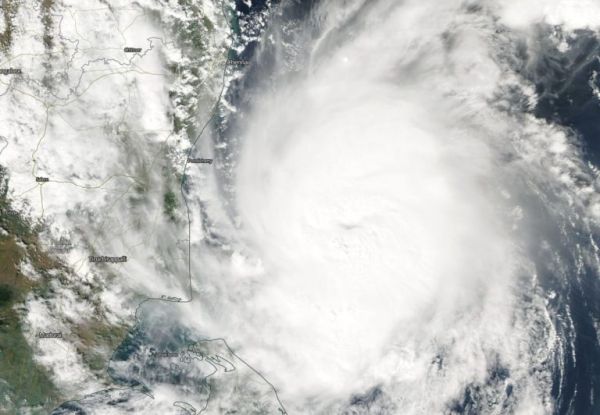
Tropical Cyclone Gaja continued to organize in the Bay of Bengal as it made its approach to southeastern India when NASA-NOAA’s Suomi NPP satellite passed overhead and captured an image. The image revealed that Gaja had developed a cloud-filled eye.
Tropical Cyclone Gaja continued to organize in the Bay of Bengal as it made its approach to southeastern India when NASA-NOAA’s Suomi NPP satellite passed overhead and captured an image. The image revealed that Gaja had developed a cloud-filled eye.
The Bay of Bengal is in the Northern Indian Ocean basin, east of India.
On Nov. 15, the Visible Infrared Imaging Radiometer Suite (VIIRS) instrument aboard NASA-NOAA’s Suomi NPP satellite took a visible light image of Tropical Storm Gaja. It revealed what appeared to be a cloud-filled eye. The Joint Typhoon Warning Center confirmed that “animated multispectral satellite imagery shows a more compact system with a dimple feature on the central convection – indicative of a formative eye.”
Read more at NASA / Goddard Space Flight Center
Image: On Nov. 15, the VIIRS instrument aboard NASA-NOAA’s Suomi NPP satellite captured a visible image of Tropical Storm Gaja in the Bay of Bengal approaching southern India (left).
CREDIT: NASA Worldview, Earth Observing System Data and Information System (EOSDIS)


