
System 94S developed about 240 miles west-northwest of Darwin, Australia on Jan. 22, 2019. The next day, it had strengthened into a tropical cyclone, and was named Riley.
System 94S developed about 240 miles west-northwest of Darwin, Australia on Jan. 22, 2019. The next day, it had strengthened into a tropical cyclone, and was named Riley. NASA-NOAA’s Suomi NPP satellite provided a look at Riley when it was closest to Australia.
When it developed on Jan. 22, the low-pressure area known as System 94S had sustained winds near 35 kilometers per hour. The Australian Bureau of Meteorology (ABM) posted a Cyclone Watch for the northwest Kimberley coast on that day.
On January 23, the ABM said Tropical Cyclone Riley continues tracking west, away from Kimberley coast. But the Tropical Cyclone Watch continued for the Pilbara coast. There was also a Blue Alert in effect for people between Whim Creek and Onslow including the towns of Roebourne, Wickham, Point Samson, Karratha, Dampier and Onslow.
Read more at NASA Goddard Space Flight Center
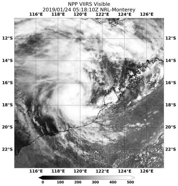
Image: On Jan. 24, 2018, NASA-NOAA’s Suomi NPP satellite passed over Riley on Jan. 23 at 1:18 a.m. EST (0518 UTC). The VIIRS instrument aboard captured a visible image that showed the storm off the northwest coast of Western Australia. The storm had taken on the comma shape of a developed storm, and the southern quadrant of the storm was lashing the coast. CREDIT: NASA


