
The polar vortex, a swirl of low-pressure air six miles up in the atmosphere, blasted much of the American Midwest and Northeast in late January 2019 with temperatures cold enough to bring on frostbite within minutes.
The polar vortex, a swirl of low-pressure air six miles up in the atmosphere, blasted much of the American Midwest and Northeast in late January 2019 with temperatures cold enough to bring on frostbite within minutes.
By Friday, February 1, the vortex and the Arctic air it funneled into cities from Fargo to Pittsburgh to Detroit had prompted days of school and business closures, thousands of flight cancellations, a halt to mail deliveries, and a smattering of power outages and pleas for reduced heating. At least 21 people died and dozens were injured in weather-related incidents. Officials warned residents to stay inside, even as meteorologists began to forecast spring-like weather and the likelihood of an 80-degree temperature swing within a few days.
It all started after the polar vortex that normally hovers over the North Pole split in two on January 2, the result of planetary waves breaking in the stratosphere, said Stanford atmospheric scientist Aditi Sheshadri.
Read more at Stanford University
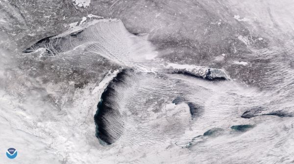
Image: When cold, Arctic air poured over the relatively warmer surface of the Great Lakes in late January 2019, it generated parallel cylinders of rising warm air and sinking cool air. One result? Cloud streets: long rows of cumulus clouds that can produce snow. (Image credit: NOAA Environmental Visualization Laboratory)


