
NASA’s Aqua satellite provided a look at the temperatures in Tropical Cyclone Wutip as it threatens Chuuk and Yap States in the Southern Pacific Ocean.
NASA’s Aqua satellite provided a look at the temperatures in Tropical Cyclone Wutip as it threatens Chuuk and Yap States in the Southern Pacific Ocean. Wutip has strengthened into a typhoon.
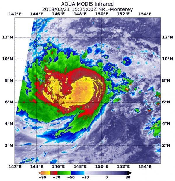
Infrared imagery provides scientists with a look at cloud top temperatures in tropical cyclones, and the colder the clouds, the higher up in the atmosphere and stronger the storms tend to be.
Infrared satellite data of Wutip was captured at 10:25 a.m. EDT (1525 UTC) on Feb. 21 from the Moderate Resolution Imaging Spectroradiometer or MODIS instrument aboard NASA’s Aqua satellite. MODIS data revealed powerful thunderstorms with cloud top temperatures as cold as minus 80 degrees Fahrenheit (minus 62.2 degrees Celsius) circling the center. Storms with temperatures that cold are indicative of strong storms and have been shown to have the capability to generate heavy rainfall.
Read more at NASA / Goddard Space Flight Center
Image: At 10:25 a.m. EDT (1525 UTC) on Feb. 21, the MODIS instrument aboard NASA’s Aqua satellite looked at Tropical Cyclone Wutip in infrared light. MODIS found coldest cloud tops (light green) had temperatures near minus 80 degrees Fahrenheit (minus 62.2 degrees Celsius) around the center of circulation. CREDIT: NASA/NRL


