
Tropical Cyclone Idai was approaching landfall in Mozambique when NASA’s Aqua satellite provided an infrared look at the cloud top temperatures to determine the strongest parts of the storm.
Tropical Cyclone Idai was approaching landfall in Mozambique when NASA’s Aqua satellite provided an infrared look at the cloud top temperatures to determine the strongest parts of the storm.
On March 14, warnings were in effect in Mozambique as Idai nears landfall. Idai will affect (parts of) the Mozambique provinces of Zambézia, Sofala, Manica and Inhambane with very strong winds (190 to 210 kilometers per hour), accompanied by very heavy rains (more than 150 mm in 24 hours) and severe thunderstorms. INAM also foresees the continuation of moderate to strong rains (30 to 50 mm / 24h), accompanied by severe thunderstorms and gusty winds north of the provinces of Niassa and Cabo Delgado.
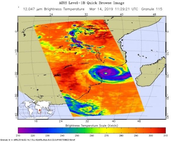
On March 14 at 7:29 a.m. EDT (1129 UTC) the Atmospheric Infrared Sounder or AIRS instrument aboard NASA’s Aqua satellite analyzed cloud top temperatures of Tropical Cyclone Idai in infrared light. AIRS found cloud top temperatures were as cold as or colder than minus 63 degrees Fahrenheit (minus 53 degrees Celsius) circling the eye. Cloud top temperatures that cold indicate strong storms that have the capability to create heavy rain.
Read more at NASA / Goddard Space Flight Center
Image: On the March 14, the AIRS instrument aboard NASA’s Aqua satellite analyzed cloud top temperatures of Tropical Cyclone Idai in infrared light. AIRS found cloud top temperatures of strongest thunderstorms were as cold as or colder than minus 63 degrees Fahrenheit (minus 53 degrees Celsius) around the eye. CREDIT: NASA JPL / Heidar Thrastarson


