
Tropical Cyclone Savannah continued to move in southerly direction in the Southern Indian Ocean and move away from Indonesia.
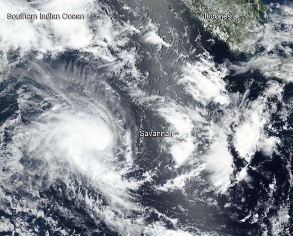
Tropical Cyclone Savannah continued to move in southerly direction in the Southern Indian Ocean and move away from Indonesia. NASA-NOAA’s Suomi NPP satellite provided a visible image of the storm. Savannah is no threat to land areas.
Savannah formed on March 14 as Tropical Cyclone 19S and once it strengthened into a tropical storm it was renamed.
Suomi NPP passed over Savannah on March 15 and the Visible Infrared Imaging Radiometer Suite (VIIRS) instrument provided a visible image of the storm. The VIIRS image showed a rounded area of storms around the low-level center of circulation with a band of thunderstorms feeding into the center, extending to the southeast. The Joint Typhoon Warning Center (JTWC) noted “animated enhanced infrared satellite imagery depicts a consolidating system with a central dense overcast feature persisting over the low-level circulation center.” A microwave image showed tightly-curved bands of thunderstorms wrapping around an eye feature, indicating the storm was strengthening.
Read more at NASA / Goddard Space Flight Center
Image: NASA-NOAA’s Suomi NPP satellite passed over the Southern Indian Ocean and captured a visible image of Tropical Cyclone Savannah on March 15, as it continued to move away from Indonesia. CREDIT: NASA Worldview, Earth Observing System Data and Information System (EOSDIS)


