
Tropical Cyclone Trevor formed in the Coral Sea of the Southwestern Pacific Ocean on March 18.
Tropical Cyclone Trevor formed in the Coral Sea of the Southwestern Pacific Ocean on March 18. NASA’s Terra satellite analyzed cloud top temperatures in the storm which gave an indication of the storm’s strength. Trevor has already triggered warnings in Queensland, Australia.
The Australian Bureau of Meteorology posted warnings on March 18. A tropical cyclone warming is in force from Orford Ness to Cooktown, and a tropical cyclone watch is in force from Cape York to Pormpuraaw. For local information, visit the Australian Bureau of Meteorology website: http://www.bom.gov.au/cgi-bin/wrap_fwo.pl?IDQ20023.html.
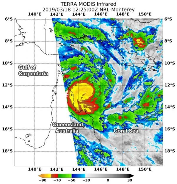
At 8:25 a.m. EDT (1225 UTC) on Mar. 18, the MODIS or Moderate Resolution Imaging Spectroradiometer instrument aboard NASA’s Terra satellite looked at Tropical Cyclone Trevor in infrared light as it moved to the Cape York Peninsula of Queensland. MODIS found coldest cloud tops had temperatures near minus 80 degrees Fahrenheit (minus 62.2 degrees Celsius) around the center of the tropical storm. Storms with temperatures that cold are indicative of strong storms and have been shown to have the capability to generate heavy rainfall.
Read more at NASA / Goddard Space Flight Center
Image: At 8:25 a.m. EDT (1225 UTC) on Mar. 18, the MODIS instrument aboard NASA’s Terra satellite looked at Tropical Cyclone Trevor in infrared light. MODIS found coldest cloud tops (light green) had temperatures near minus 80 degrees Fahrenheit (minus 62.2 degrees Celsius) around the center of the tropical storm. CREDIT: NASA / NRL


