
Tropical Cyclone 23S has developed north of the Kimberley coast, and generated warnings.
Tropical Cyclone 23S has developed north of the Kimberley coast, and generated warnings. NASA-NOAA’s Suomi NPP satellite passed overhead as the low pressure area consolidated into a tropical cyclone.
23S is expected to be renamed Tropical Storm Wallace as it falls in Australia’s area of responsibility, and follows their naming list.
The Australian Bureau of Meteorology or ABM posted warnings from Kalumburu to Beagle Bay, not including Derby.
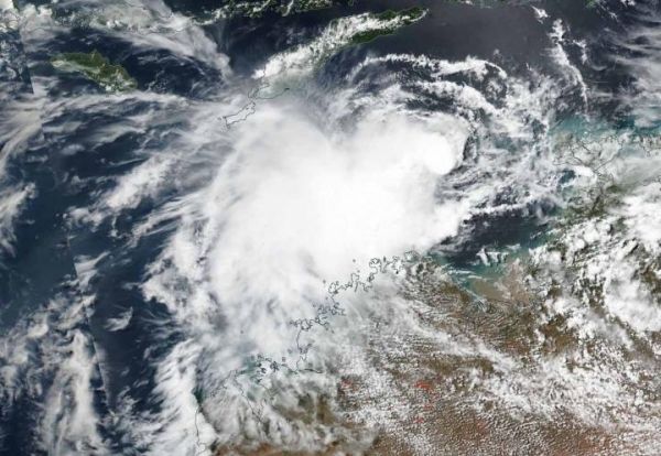
NASA-NOAA’s Suomi NPP satellite passed over 23S on April 5 and the Visible Infrared Imaging Radiometer Suite (VIIRS) instrument provided a visible image of the storm. The VIIRS image showed an elongated storm. The southeastern quadrant of 23S was over the Kimberly coast. The Joint Typhoon Warning Center or JTWC noted “animated multispectral satellite imagery which depicts isolated, deep central convection and shallow rain bands.”
Read more at NASA/Goddard Space Flight Center
Image: NASA-NOAA's Suomi NPP satellite passed over the Southern Indian Ocean and captured a visible image of Tropical Cyclone 23S or Wallace, on April 5, as skirted the coast of Western Australia. (Credit: NASA Worldview, Earth Observing System Data and Information System (EOSDIS)).


