
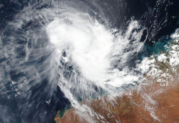
NASA-NOAA’s Suomi NPP satellite passed over the Southern Indian Ocean and captured a visible image of what appeared to be a more organized Tropical Cyclone Wallace, off the coast of Western Australia.
NASA-NOAA’s Suomi NPP satellite passed over the Southern Indian Ocean and captured a visible image of what appeared to be a more organized Tropical Cyclone Wallace, off the coast of Western Australia.
The Australian Bureau of Meteorology or ABM noted that only a High Seas Warning was in effect off the coast of Western Australia, as Wallace continues to track away from the coast.
NASA-NOAA’s Suomi NPP satellite passed over Wallace on April 8 and the Visible Infrared Imaging Radiometer Suite (VIIRS) instrument provided a visible image of the storm. The VIIRS image showed bands of thunderstorms from the western to the southern quadrants.
ABM noted on April 8 “An eye is starting to emerge on the most recent imagery with the system adopting a more circular appearance.” At 5:43 a.m. EDT (0943 UTC) satellite imagery showed strong convection (rising air that forms thunderstorms that make up a tropical cyclone) partially wrapping around the center to the west and south of the center.
Read more at NASA / Goddard Space Flight Center
Image: NASA-NOAA’s Suomi NPP satellite passed over the Southern Indian Ocean and captured a visible image of Tropical Cyclone Wallace, on April 8, as it continued to move away from the coast of Western Australia. CREDIT: NASA Worldview, Earth Observing System Data and Information System (EOSDIS).


