
NASA’s Aqua satellite focused an infrared eye on a very powerful Tropical Cyclone Fani as it approached landfall in northeastern India.
NASA’s Aqua satellite focused an infrared eye on a very powerful Tropical Cyclone Fani as it approached landfall in northeastern India. Fani is a powerful Category 4 hurricane on the Saffir-Simpson Hurricane Wind Scale.
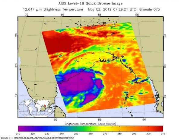
On May 2 at 3:29 a.m. EDT (0729 UTC), the Atmospheric Infrared Sounder or AIRS instrument aboard NASA’s Aqua satellite analyzed cloud top temperatures of Tropical Cyclone Fani in infrared light. AIRS found cloud top temperatures of strongest thunderstorms as cold as or colder than minus 80 degrees Fahrenheit (minus 62 degrees Celsius) circling the eye and in a fragmented band of thunderstorms east of the center. Satellite data showed there is now a 16 nautical mile-wide round, symmetrical eye surrounded by a thick band of powerful thunderstorms. Cloud top temperatures that cold indicate strong storms that have the capability to create heavy rain.
Read more at NASA / Goddard Space Flight Center
Image: On May 2 at 3:29 a.m. EDT (0729 UTC), the AIRS instrument aboard NASA’s Aqua satellite analyzed cloud top temperatures of Tropical Cyclone Fani in infrared light. AIRS found cloud top temperatures of strongest thunderstorms were as cold as or colder than minus 80 degrees Fahrenheit (minus 62 degrees Celsius). CREDIT: NASA JPL / Heidar Thrastarson


