
Satellite data revealed heavy rainfall in powerful Tropical Cyclone Fani before it made landfall in northeastern India.
Satellite data revealed heavy rainfall in powerful Tropical Cyclone Fani before it made landfall in northeastern India. Fani brought that soaking rain to the region and continues to drop heavy rainfall on May 3, as it moves toward Bangladesh.
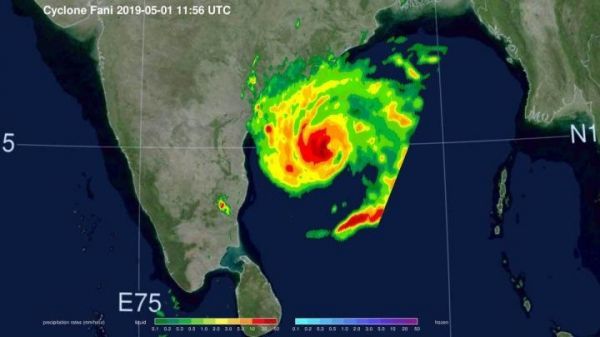
NASA’s GPM or Global Precipitation Measurement mission satellite provides information on precipitation from its orbit in space. On May 1 at 7:56 a.m. EDT (1156 UTC), the GPM Core Observatory captured an overpass of the powerful storm as it continued strengthening and moving toward landfall. A 3D image and a color-enhanced rainfall image were created at NASA’s Goddard Space Flight Center in Greenbelt, Maryland. The images showed how high thunderstorms stretched into the troposphere and measured rainfall rates. GPM found that some of the heaviest rainfall rates were up to 50 millimeters (2 inches) per hour and were in the western quadrant of the storm.
GPM is a joint mission between NASA and the Japan Aerospace Exploration Agency or JAXA. GPM also utilizes a constellation of other satellites to provide a global analysis of precipitation of rainfall around the world.
Read more at NASA/Goddard Space Flight Center
Image: The GPM core observatory satellite passed over Tropical Cyclone Fani on May 1, 2019 as it was strengthening and nearing landfall in northeastern India. This image shows the powerful storms circling the center that were producing rainfall at a rate greater than 50 mm/2 inches per hour (red). (Credit: NASA/JAXA/Jacob Reed)


